
Return To Running Challenge 2 is going to span a few weeks. The Landmark Challenge will see a series of local (and not so local) landmarks shared on here and in the Facebook closed group with a link to their Google Maps location.
The challenge is simply to run to the landmark and get your photo taken there. Easy.
Roolz
- You need to run a minimum of three times in the week, any duration/distance is fine for two of the runs (as long as you are in your running kit)
- At least one of the runs has to include the landmark shown, you need to get a photo at that location so it might be best to arrange to run with one other person. Your landmark run should be a minimum of 30 minute run.
- Post your landmark photo in the comments section on facebook or using the file upload feature at the bottom of this blog.
Some rules about the landmarks:
- Don’t trespass. You can choose which route you take to get to the landmark but don’t go getting into trouble!
- You might find some of them very muddy! Be prepared with suitable running kit.
- The landmarks are mostly Essington-centric, but some are spread out to give longer runners a bit of a challenge, and for members who live further away don’t have to come to Essington every time.
- I’ll try to post a mix of locations, you don’t have to do them all and you can be creative with how you get to them, so long as you do a 30 minute run including the landmark.
- All the landmark locations will remain visible so you can go back and do a previous landmark if you want.
- I’ll post new landmarks irregularly but you should get notified when I add a new one.
- ONLY ONE LANDMARK PER RUN! it’s not a competition to see who can tick them all off (well, it is sort of)
- You can do more than one landmark per week though, just on different runs.
- Have fun, be safe.
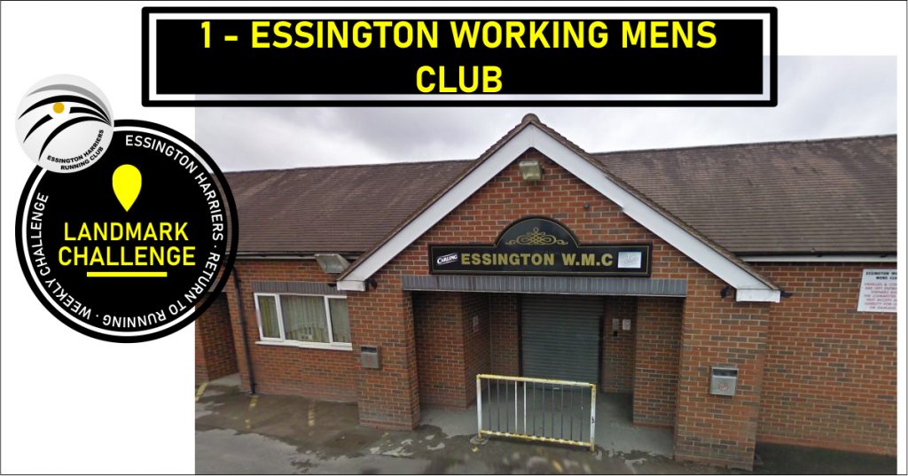
1 Essington Working Mens Club
- Approximate distance from WMC: 0km
- Surface: Road
- Suggested Route: Everyone should know this one!
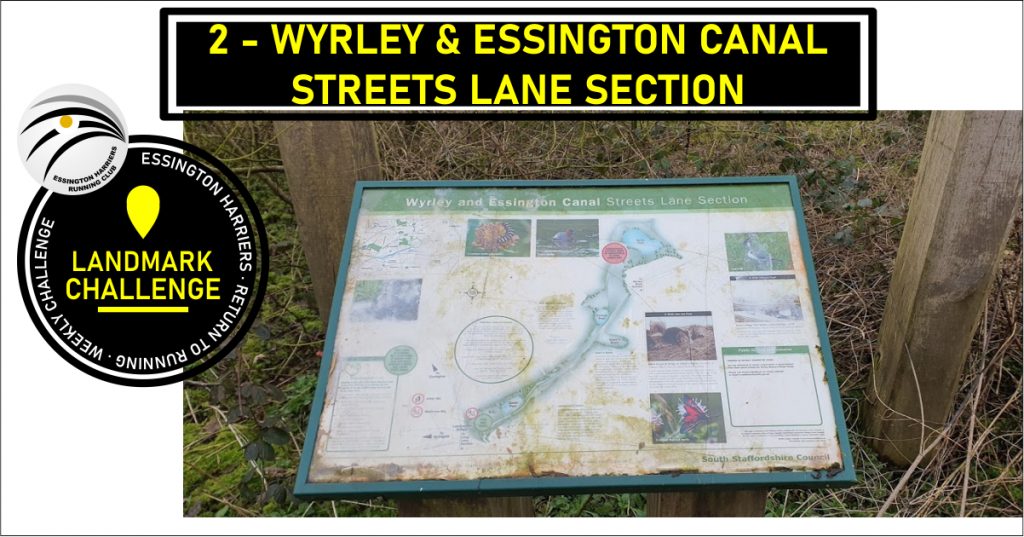
2 Wyrley & Essington Canal Streets Lane Section
- Approximate distance from WMC: 4.5km (9km out and back)
- Surface: Road
- Suggested Route: From WMC run past the lakes and out onto Brownshaw Lane, turn left and up onto Wolverhampton Road, keep right and head towards St. John’s. Turn right at the mini island and head out along the Hobnock Road over the motorway. At the mini island on Bursnips Road, cross over and turn left towards Cheslyn Hay. Turn right down Broad Lane and take the first left onto Long Lane. The footpath runs out here so make sure you are visible while running on the road. Take the first left onto New Landywood Lane. At the end of New Landywood Lane, cross over Old Landywood Lane and the gate to the landmark is immediately in front of you.
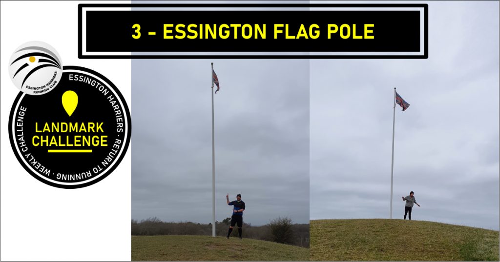
3 Essington Flag
https://goo.gl/maps/EE3fg8cDQiKX2CAC9
- Approximate distance from WMC: 1.7km (3.2km out and back)
- Surface: Road & fields (potentially very muddy)
- Suggested Route: From WMC run past the lakes and out onto Brownshaw Lane, turn left and up onto Wolverhampton Road, keep right and head towards St. John’s. Turn right at the mini island and head out along the Hobnock Road but don’t go over the motorway bridge, take the metal gate into the field to the right (past The Steadings housing estate, opposite The School Farm) Run along the field to the flagpole at the far end. The field is muddy and slippery so be careful!
- *NOTE You can reach this one from Rowan Drive, off Larchmere Drive, but the path is very narrow, very muddy and has a barbed wire fence running alongside*
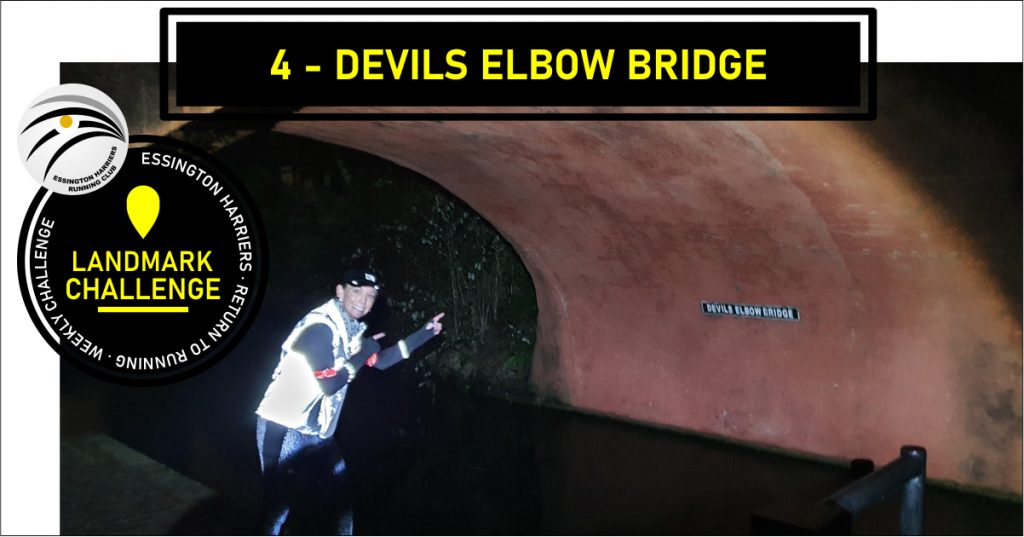
4 Devils Elbow Bridge
- Approximate distance from WMC: 3km (6km out and back)
- Surface: Mostly Road
- Suggested Route: From WMC run down High Hill and turn right onto Kitchen Lane. Run down Kitchen Lane, the the bottom turn left onto Linthouse Lane. At the traffic island, take the road to the right, White House Avenue. Follow this road down onto the footpath over the canal. This is Devils Elbow Bridge. come off the bridge and turn right under it to get to the bridge name.
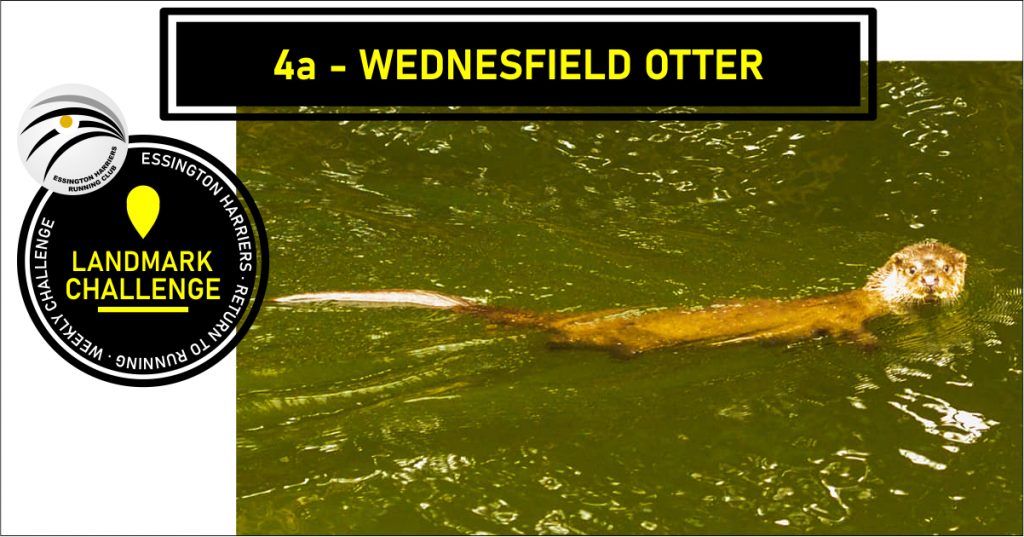
BONUS LANDMARK!
An otter has been spotted in the canal, while it was up closer to Bently Bridge where it was spotted, you may get to see it coming down the the canal! If not, look out for the swans who are nesting slightly further along the canal towards Wednesfield.
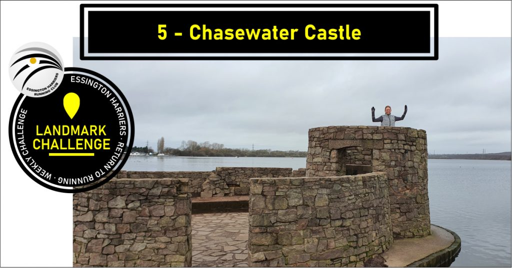
5 Chasewater Castle
https://goo.gl/maps/z7NXMbdLEcED8zUw8
- Approximate distance from WMC: 7.4 Miles (14.8 Return)
- Surface: Path
- Suggested Route:
- From WMC exit via the pools, then turn left onto Brownshaw Lane, follow up and turn right onto Wolverhampton Road.
- At the min traffic island, turn right onto Hobnock Road, follow to the end.
- Turn left onto Bursnips Road, the turn left onto Broad Lane at the traffic lights.
- Take the first left onto Long Land, then the first left onto new Landywood Lane, follow to the end.
- Turn right onto Strawberry Lane and follow to the end.
- Turn left onto Stafford Road (A34) and then first right onto Jacobs Hall Lane. Follow to the end.
- Turn right onto Gains Lane, follow to the right onto Gorsey Lane and follow to the end.
- Turn left onto Lime Lane, follow to the end.
- At the traffic island, turn right onto A5 Watling Street.
- At the Rising Sun Island, take the first exit onto Wilkin Road and follow to the end, turn left onto Hendsford Road then right just past Poole Crescent onto the footpath.
- Follow the footpath up and over the M6 Toll Road and down to Chasewater Carpark.
- Crossover the road and the castle jetty is immediately in front of you.
- Chasewater – from the main carpark on Pool Lane head clockwise, the castle is set on a short jetty just past the loop that is the Parkrun start/finish location.
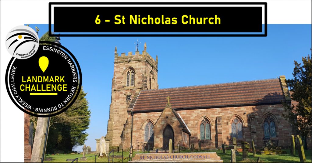
6 St Nicholas Church
https://goo.gl/maps/mVvUKSX6G4GfC9BJA
- Approximate distance from WMC: 7.2 Miles (14.4 Return)
- Surface: Road
- Suggested Route:
- From WMC head down High Hill and turn right onto Kitchen Lane.
- Follow to the bottom and turn right onto Linthouse Lane.
- Follow to the traffic island and go straight over onto Lower Prestwood Road.
- Take the second right onto Blacwood Avenue and follow to the end.
- Turn left onto Blackhalve Lane and then right onto Belton Avenue, follow to the end.
- Turn left onto A460 then right onto Underhill Lane, follow to end by Northycote Farm (might be a bit hilly!)
- At the mini traffic island, take the road to the right, Legs Lane.
- At the traffic island take the first exit, staying on Legs Lane.
- Go over at the next traffic island, onto Primrose Avenue.
- Take the second Right onto Primrose Avenue towards the train track bridge.
- Follow onto Cottage Lane, follow to the end.
- Turn left onto Bee Lane, cross over the Stafford Road at the traffic island, onto Wobaston Road.
- Stay on Wobaston Road/Pendeford Mill Lane into Bilbrook.
- Take the first right past the recycling centre onto Joeys Lane and follow to the end.
- Turn right onto Bilbrook Road and follow to the end.
- Turn left at the traffic island and then right onto Sandy Lane.
- St Nicholas is at the top of Sandy Lane.
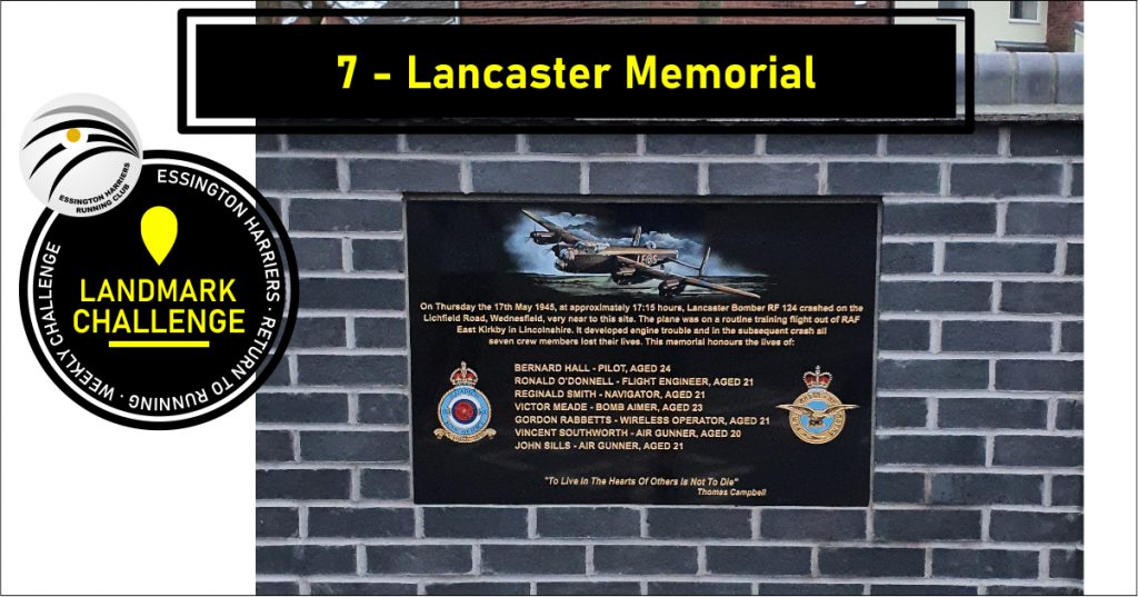
7 Lancaster Memorial
https://goo.gl/maps/yi44fHhJe838sCmc7
- Approximate distance from WMC: 2.3 Miles (4.6 Return)
- Surface: Road
- Suggested Route: From WMC head down High Hill and turn left down Kitchen Lane, follow to the bottom. Turn left onto Linthouse Lane and then head right at the traffic island to stay on Linthouse Lane. At the next traffic island, turn right onto the Lichfield Road. The memorial is at the entrance to the Perry Hall Park on the left past the pedestrian crossing.
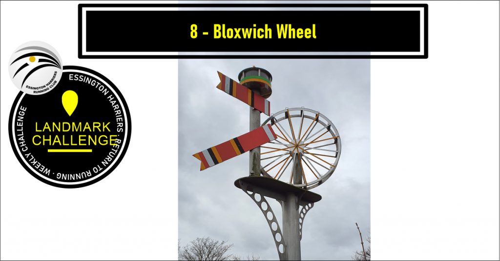
8 Bloxwich Wheel
https://goo.gl/maps/5DzcKy3SB9URRmcd6
- Approximate distance from WMC: 3.3 Miles (6.6 Return)
- Surface: Road
- Suggested Route: From WMC head down High Hill and continue down Snyed Lane. At the traffic island at the bottom, turn left onto the Lichfield Road. Follow along to Sir Robert Peel crossroads, the turn left. Run toward Broad Lane, the wheel is on the train track bridge.
- Note this is also a well know Strava segment coming the other way, starting at the road junction and going over the bridge.
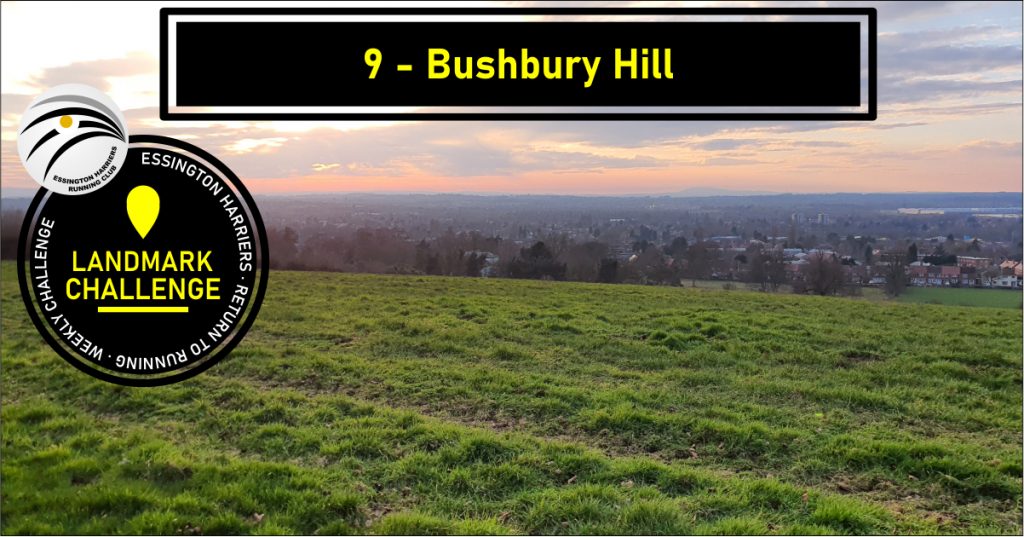
9 Bushbury Hill
https://goo.gl/maps/JggRiBH5JXR1hKLZ8
- Approximate distance from WMC: 2.9 Miles (5.18 Return)
- Surface: Road/path
- Suggested Route:
- From WMC head down High Hill and turn right onto Kitchen Lane.
- Follow to the end and turn right onto Linthouse Lane.
- Follow to the island and turn left onto Wood End Road.
- At the traffic lights, turn left onto Blackhalve Lane.
- Take the first right onto Belton Avenue.
- At the end, cross over the Cannock Road ont Underhill Lane.
- Run up to the mini island, then take the path to the left (on the right-hand side of Wildtree Avenue
- Continue up the path to the very top.
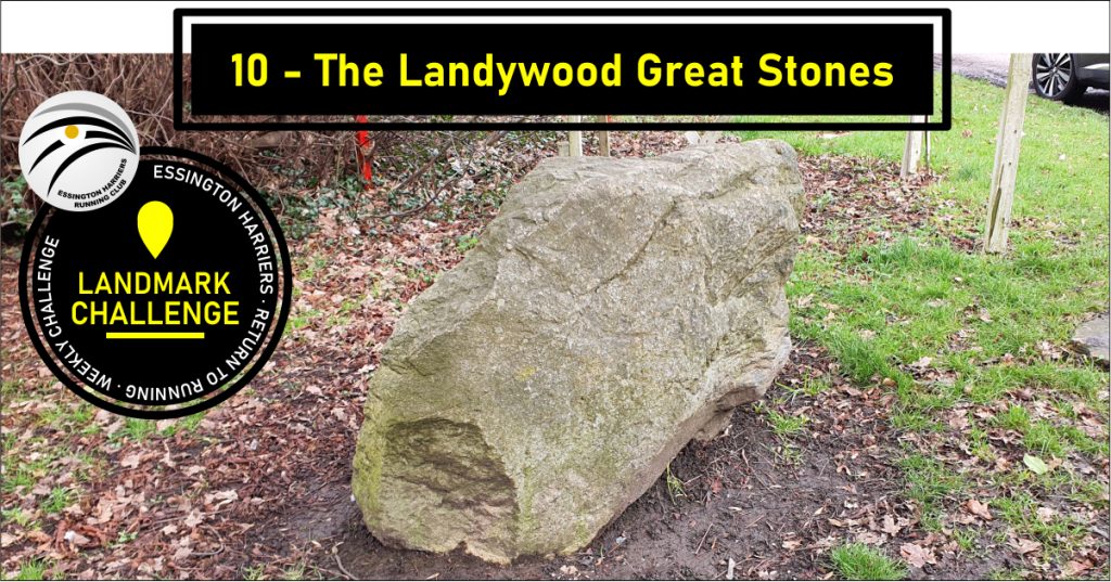
10 Landywood Great Stones
Once a monument of giant neolithic stones, now only part of one remains.
https://goo.gl/maps/4GMakJfTE8ifSg4PA
- Approximate distance from WMC: 2.8 Miles (5.16 Return)
- Surface: Road/path
- Suggested Route:
- From WMC head out past the school on Hobnock Road and over the M6.
- Follow to the end and turn Left onto Bursnips Road.
- At the traffic lights, turn Right down Broad Lane.
- Take the first Left onto Long Lane, then the first Left again onto New Landywood Lane.
- Follow to the end and turn Right onto Old Landywood Lane.
- Follow the road along (careful, there are no paths in some section) past the Malt at Landywood pub and the first lot of industrial units until the road starts to bend to the right.
- The last remaining great Landywood stone can be found on the left hand side but the junction into Landywood Enterprise Park.
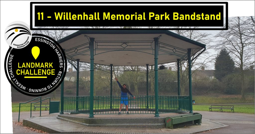
11 Willenhall Memorial Park Bandstand
https://goo.gl/maps/Zj1c6AvBzGzfa2Zo6
- Approximate distance from WMC: 3.6 Miles (7.2 Return)
- Surface: Road/path
- Suggested Route:
- From WMC head down High Hill to the traffic lights.
- Turn Right and head down the Essington Road.
- Cross straight over at the New Invention traffic island and continue down the Cannock Road.
- Continue straight at the mini island onto Coppice Lane.
- Stay on that road (Coppice Lane/Lucknow Road/Monmer Lane)
- At the traffic island, go straight over oneo Bloxwich Road south.
- At the next mini island, head left onto Temple Bar, then at the next island head right onto Field Street.
- Use the entrance off Pinson Road to go into the memorial park, the bandstand in to the right as you go in.
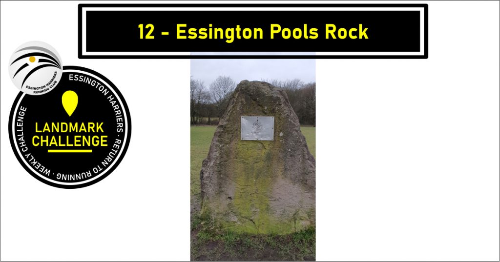
12 Essington Pools Rock
https://goo.gl/maps/rYZfPKm61dnpXL7Y9
- Approximate distance from WMC: 0.4 Miles (0.8 Return)
- Surface: Path/Field
- Suggested Route:
- From WMC head out the back gate to Essington Pools
- Follow around Brown Pool Lakes to the carpark on Brownshaw Lane
- The rock is located in the field near the carpark.
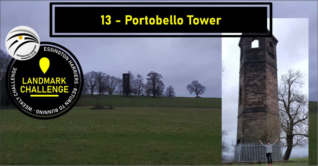
13 Portobello Tower
https://goo.gl/maps/4eyLhTSxpJ9GkQgj8
Portobello tower is located in the old grounds of Hilton Hall, there are a number of ways to get to the tower which might cross private property so check the route and access first if you’re not following the route below.
- Approximate distance from WMC: 6.3km (3.96Miles)
- Surface: road/Path/Field
- Suggested Route:
- From WMC head out the back gate to Essington Pools
- Exit Essington Pools left onto Brownshaw Lane.
- Follow up and slight right onto Wolverhampton Road
- At the mini island, head right on Hobnock Road, follow out over the motorway.
- At the end, turn left onto Bursnips Road.
- Follow on Bognop Road around to Hilton Lane, turn left onto Hilton Lane.
- Follow Hilton lane and take the 4th Left (UK Paintball)
- Follow the path down and slight left/slight right to go around Hilton Hall.
- the path turns sharp right at the end of Hilton Hall car park, along a field, take the path to the left by the coppice.
- There may be some mud on here – best not jump in it, it’s very dubious mud. Once you pass through the gate, Portobello Tower is on your left at the top of the hill near the coppice.
Comments